 Walkability is a very desirable characteristic when it comes to livability. Being able to walk, bike or hop aboard transit is high on the wish list of those who want to reduce their carbon footprint and connect to their neighborhood.
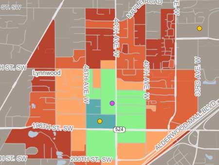
With this in mind, Nat Henry created a new interactive tool to help Seattleites see just how walkable their location is. Find your location on the Close interactive tool, select what you’re looking for (store, restaurant, etc.), and get a quick overview of how walkable your community is. The tool’s grid is even color-coded to make it easy to see which areas are the most walkable (blue or green) and least (red and gray).
When Nat created the map out of curiosity, he had no idea how popular it would be. After its release, he got so many compliments and questions that he decided to leave his statistics analyst job at the University of Washington and strike out on his own.
In early April, the expanded version of Close was officially released. It covers every block in the United States, showing you just how far that supermarket, library or other destination is, whether you plan to hoof it, bike it or jump aboard transit.
That’s a tremendous lift, even for a large team. The fact that Nat did it on his own is nothing short of amazing.
The idea behind it is the urban planning concept known as the “15-minute city,” which proposes that everyone should be able to meet their basic needs within 15 minutes of their home.
Close contains 3.2 million destinations spread across 7.9 million U.S. blocks. The tool includes grocery stores, libraries, schools, playgrounds, bars, restaurants, bookstores, and dentists. The walking, biking and transit times are based on a conservative estimate so that actual times may vary.